The Open Parcel Viewer is a client-side application written in plain javascript and jquery. It is capable of rendering up to 50k polygons on desktop and mobile. The app uses Leaflet as the mapping api and Jekyll as a build tool. Color, initial map center/zoom and the search field can be defined i...
This simple, responsive store locator is based on the original Mapbox JS example, tweaked to use Leaflet 1.0 and custom icons. The sidebar uses a jQuery filter function (thanks jsfiddle). The nearest store function uses TurfJS, b...
This presentation was given at the Northeast Ohio GIS Sympoisum on August 25, 2016. The primary objective was to give an overview of using LeafletJS in the real world, using actual data. In addition, I show a quick example using ...
Update 2017-08-01 This app has seen two more iterations. These each utilize an mbtiles-server to host the vector tiles, but still use client-side search for the data. The updated examples can be viewed here - a Leaf...
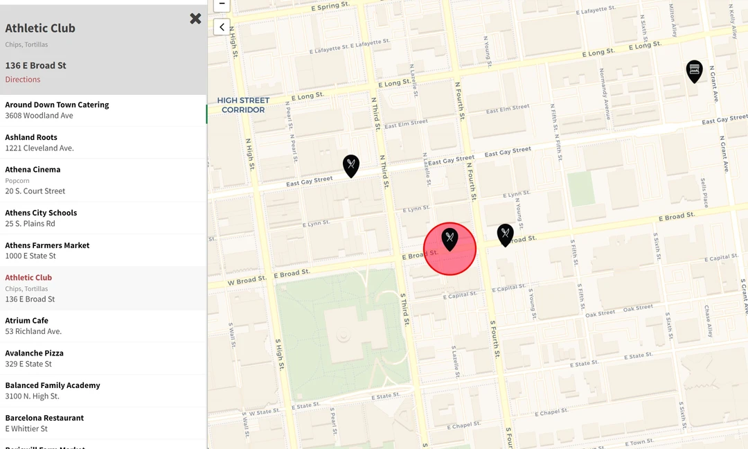
Using the original Mapbox JS store locator example as a starting point, the Shagbark map adds a couple of unique features including store text search and a nearest store locator. The project pulls data from a Google Sheet in NodeJS while building. This allows the client to easily update store locations and available products. Custom icons with the client logo are used to mark store locations. An open source version of this store locator is available on GitHub.
This is my take on a more modern looking leaflet toolbar/ui. With leaflet-search as the base, and a few short lines of css, I have customized the .leaflet-top.leaflet-left class so that it adds tools across the top of the screen, with ...
One of the benefits of using the open source Leaflet mapping library is the wide variety of available community supported plugins. This simple map uses two great plugins - Leaflet Elevation and ...
Update: This map originally used Google’s Picasa Web API, but this will soon be shut down. Instead of migrating to another Google service, I simply extracted the EXIF data from the photos (...
This is a quick look at Leaflet, Google MyMaps and Esri’s ArcGIS Online....
GitHub will host and preview your geojson files! Geomusings gives a good explanation of some pros and cons. Here is an example of a geojson stored on GitHub, then shared. GitHub takes care of the rendering via ...